What We Review
Introduction
Global wind patterns profoundly influence weather, climate, and various ecological processes. They arise from the uneven heating of Earth’s surface, the planet’s rotation, and the interaction of large-scale atmospheric cells. These winds do more than just move air around; they also carry moisture, shape ocean currents, and even affect the distribution of energy resources such as wind power. Furthermore, studying global wind patterns helps illustrate how solar radiation, atmospheric dynamics, and Earth’s rotation work together to create distinct climate zones. Therefore, this topic remains highly relevant to AP® Environmental Science, aiding learners in understanding key principles behind weather systems and the movement of air across the globe.
What Are Global Wind Patterns?
Global wind patterns refer to large-scale movements of air that occur in Earth’s atmosphere. They develop because tropical regions receive more intense solar radiation than polar regions. As a result, warmer air near the equator tends to rise, while cooler air near the poles tends to sink. This contrast in air density propels atmospheric circulation, redistributing heat around the planet.
Several factors shape these wind patterns. First, uneven heating of the surface creates temperature gradients. Next, the rotation of the Earth adds a degree of deflection to these moving air masses. Finally, the structured circulation cells—Hadley, Ferrel, and Polar—combine to produce predictable wind belts such as the Trade Winds. Thus, global wind patterns serve as both the product of solar input and the driver of planet-wide climate conditions.
How Solar Radiation Affects Wind Patterns
Solar radiation is greatest near the equator because the Sun’s rays strike this region more directly than at higher latitudes. Near the poles, sunlight hits at a lower angle, delivering less energy per unit area. This temperature difference sets up contrasting air masses: warmer at lower latitudes and cooler at higher latitudes.
Consequently, warm air near the equator expands and becomes less dense. This air rises, creating areas of low pressure at Earth’s surface. At higher altitudes, this air eventually cools and moves toward cooler latitudes, where it then sinks. Over land and water, similar temperature differences arise. For instance, continental areas might heat more quickly than adjacent bodies of water during daytime, causing localized wind patterns. However, on a larger scale, the primary engines of wind remain the differences in solar heating along latitudinal gradients.
Step-by-Step Example: Heating of Land vs. Water
- Solar radiation increases daytime temperatures more on land than water because land has a lower heat capacity.
- Warmer air over land rises, creating a localized low-pressure region.
- Cooler air from over the water moves inland to fill this low-pressure area, generating a seaside breeze.
- At night, the process reverses since land cools faster than water, resulting in an opposite airflow.
The Coriolis Effect Explained
The Coriolis effect is the apparent deflection of moving air masses due to Earth’s rotation. Although wind generally travels from high-pressure areas to low-pressure areas, the planet’s constant rotation shifts the path of moving air to the right in the Northern Hemisphere and to the left in the Southern Hemisphere. In essence, the Earth spins underneath the moving air, and this relative motion yields an apparent curve.
Mathematically, the Coriolis parameter can be expressed as f = 2\Omega \sin(\phi), where \Omega is the angular velocity of Earth’s rotation and \phi is latitude. Therefore, the Coriolis effect is zero at the equator (where \sin(0) = 0) and increases with latitude.
Step-by-Step Example: Wind Deflection in Different Hemispheres
- Air begins to move from a region of high pressure toward a region of low pressure.
- As the Earth rotates, the path of the moving air shifts to the right in the Northern Hemisphere.
- In the Southern Hemisphere, however, the apparent shift is to the left.
- This deflection becomes more pronounced at higher latitudes, influencing storm tracks and overall climate patterns.
Major Global Wind Patterns
Several primary wind belts encircle the globe, each with distinct characteristics. Trade Winds, for instance, occur near the equator and blow generally east to west. Westerlies typically form in mid-latitudes, traveling from west to east, while Polar Easterlies develop at high latitudes with a primarily east-to-west flow. These wind belts are crucial in shaping weather systems, in part because they guide storm fronts, distribute oceanic heat, and drive rainfall patterns.
- Trade Winds: These form in both hemispheres, typically between about 0° and 30° latitude. They are consistent and relatively strong near the equator. Therefore, they historically influenced global sailing routes.
- Westerlies: Located between approximately 30° and 60° latitude, these winds blow from the west toward the east. They steer mid-latitude cyclones and can carry moisture-laden air inland, affecting temperate climate zones.
- Polar Easterlies: Found roughly between 60° latitude and the poles, these winds blow from the east toward the west. They are generally cold and dry, reflecting the conditions of the surrounding polar regions.
Example: The Impact of Trade Winds on Tropical Weather
Trade Winds play a significant role in tropical regions. They move warm, moist air across the oceans, promoting cloud formation and storms. Over the Atlantic, for instance, these winds can influence the development of tropical cyclones. Warm, rising air feeds into the formation of organized storm systems, which then follow established wind belts, sometimes making landfall with significant rainfall and strong winds.
Atmospheric Circulation Cells
In addition to wind belts, Earth’s air masses are organized into three major circulation cells in each hemisphere: Hadley, Ferrel, and Polar cells. Together, they transport warm air from tropical areas to higher latitudes, and cooler air from the poles back toward the equator.
- Hadley Cells: Extend from the equator to about 30° latitude. Warm air rises near the equator, moves aloft toward higher latitudes, and eventually cools. After cooling, it sinks around 30° latitude, forming high-pressure zones known for arid conditions.
- Ferrel Cells: Sit between about 30° and 60° latitude. These cells are less direct, since they arise partly from the interplay of the Hadley and Polar cells. They feature rising air at around 60° latitude and sinking air near 30°, correlating with the Westerlies wind belt.
- Polar Cells: Cover high latitudes from about 60° to the poles. In these regions, cool air sinks at the poles and travels toward mid-latitudes, eventually rising again around 60° latitude.
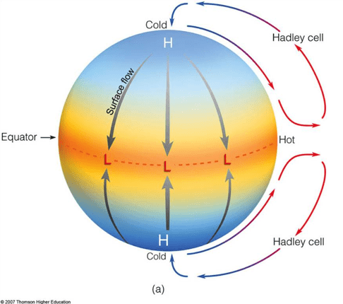
Step-by-Step Breakdown of a Hadley Cell
- Solar radiation most intensely heats equatorial regions.
- Warm, less dense air rises, creating a low-pressure zone.
- The rising air travels aloft toward higher latitudes and gradually cools.
- After cooling, the air becomes denser and sinks around 30° latitude.
- The sinking air forms a high-pressure zone, converging at the surface to replace the rising air at the equator.
- Trade Winds result from this cycle as surface air flows back toward the equatorial low-pressure zone.
Effects of Global Wind Patterns
Global wind patterns critically shape weather and climate across all continents. They carry moisture across vast oceans, driving precipitation in areas such as tropical rainforests. In contrast, descending air in high-pressure zones influences more arid regions, explaining why deserts often form near 30° latitude. Furthermore, these wind patterns impact ocean currents, guiding phenomena such as upwellings, which enhance nutrient delivery to marine ecosystems. Therefore, regional ecosystems develop in response to wind-driven temperature and moisture distributions.
Additionally, these patterns play a role in global energy considerations. The consistent airflow in jet streams and Trade Winds can be harnessed by renewable energy technologies such as wind turbines. Consequently, areas with strong and stable wind belts often become prime locations for wind farms, linking atmospheric circulation directly to human energy needs.
Example: Rainfall Distribution
- Warm, humid air near the equator rises, forming clouds and heavy rain in tropical regions.
- The moist air travels aloft and cools, eventually descending around 30° latitude.
- This descending dry air leads to deserts such as the Sahara in North Africa.
- Meanwhile, mid-latitude systems guided by Westerlies often bring moderate precipitation to temperate zones.
Conclusion
Global wind patterns emerge from the interplay of solar radiation, Earth’s rotation, and the structured arrangement of atmospheric circulation cells. The most intense solar radiation arrives at the equator, setting warm air into motion and establishing crucial wind belts. However, the Coriolis effect adds deflection, ensuring that wind tracks vary by hemisphere. Trade Winds, Westerlies, and Polar Easterlies, along with Hadley, Ferrel, and Polar cells, together shape climate zones, precipitation levels, and even ocean currents. Understanding these patterns illuminates the broader dynamics of weather and explains why certain regions are dry while others are humid and storm-prone.
Key Vocabulary
- Global wind patterns: Large-scale movements of air created by uneven heating of Earth’s surface and Earth’s rotation.
- Coriolis effect: The apparent deflection experienced by moving objects on a rotating planet, shifting wind paths to the right in the Northern Hemisphere and to the left in the Southern Hemisphere.
- Solar radiation: The energy from the Sun that drives temperature differences across latitudes, influencing atmospheric circulation.
- Atmospheric circulation: The global system of rising and sinking air masses that redistributes heat.
- Trade Winds: Persistent easterly winds near the equator, shaped by Hadley cells and the Coriolis effect.
Sharpen Your Skills for AP® Environmental Science
Are you preparing for the AP® Environmental Science test? We’ve got you covered! Try our review articles designed to help you confidently tackle real-world AP® Environmental Science problems. You’ll find everything you need to succeed, from quick tips to detailed strategies. Start exploring now!
- AP® Environmental Science: 4.1 Review
- AP® Environmental Science: 4.2 Review
- AP® Environmental Science: 4.3 Review
- AP® Environmental Science: 4.4 Review
Need help preparing for your AP® Environmental Science exam?
Albert has hundreds of AP® Environmental Science practice questions, free response, and full-length practice tests to try out.


