What We Review
Introduction to Watersheds
A watershed is an area of land in which all water drains to a common point, such as a river, lake, or ocean. Therefore, it can be thought of as a funnel that collects precipitation and channels it into a single pathway. Environmental scientists devote much time to studying watersheds because they directly affect water quality, wildlife habitats, and sustainable water supply. Understanding watershed meaning and how each watershed functions can help in designing conservation measures that protect both local and global water resources
Watersheds are essential in AP® Environmental Science since they highlight the movement and distribution of water within ecosystems. Additionally, they help explain patterns of runoff, erosion, and pollution transport. A healthy watershed is indispensable for clean drinking water, fertile soils, and balanced ecosystems.
What Is a Watershed?
A watershed, often referred to as a drainage basin, includes the physical landscape where surface water converges. It contains several components:
- Hilltops and ridges that shape water flow.
- Streams, rivers, and floodplains where water travels.
- Low-lying areas, such as ponds or lakes, that collect water.
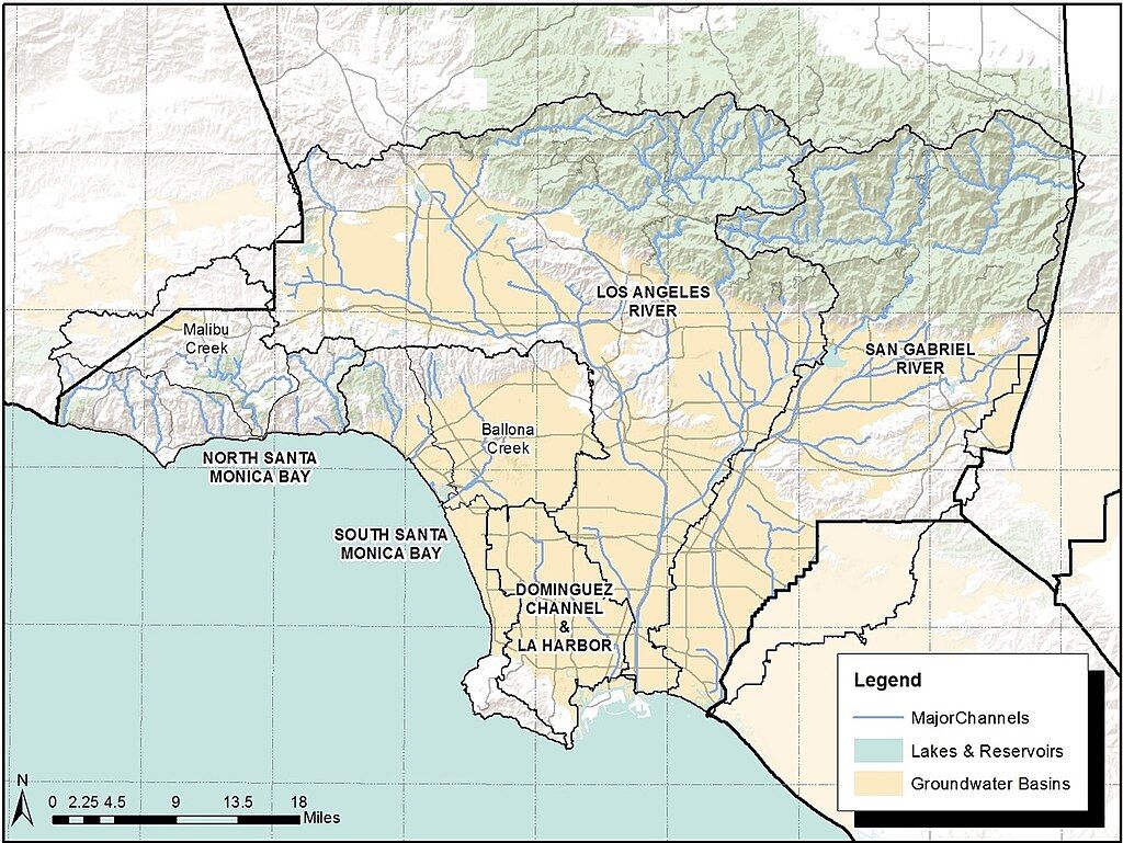
In a simple visual, imagine rain falling on a sloped surface of land. Eventually, that water flows downhill into brooks, then into larger streams, and finally into main rivers that may drain into the ocean. Each boundary between land slopes is known as a divide, marking where water flows into different basins.
Characteristics of a Watershed
Watersheds can be described using several important characteristics, including area, length, slope, soil, vegetation types, and divides. These properties directly influence runoff patterns, water storage, and ecosystem functions.
Area
The area of a watershed refers to the total surface it covers. Larger watersheds collect more water overall, potentially supporting bigger streams or rivers. Consequently, these larger basins can move more precipitation and often host multiple sub-watersheds within them.
Example: Calculating the Area of a Simple Watershed
When a watershed is roughly rectangular, you can estimate its area by multiplying its length by its width. For instance:
- Suppose a watershed is approximately 10 km long.
- Its average width is about 5 km.
- Therefore, the total watershed area (A) can be estimated as: A = 10,\text{km} \times 5,\text{km} = 50,\text{km}^2.
This simplified calculation is useful for quick approximations. However, real-world watersheds are rarely perfect rectangles, so actual measurements often rely on maps and more detailed geographic data.
Length
Watershed length is the distance from its highest point (the headwaters) to its outlet. Longer watersheds typically have extended channels for water to flow, which can slow down or speed up the movement of water, depending on the terrain.
Example: Finding the Length and Its Impact on Water Flow
- Identify the headwaters (where the main river or stream begins).
- Measure the distance along the watercourse to the river’s mouth or endpoint.
- If a watershed is very elongated, water might take more time to travel downstream—allowing more infiltration into the soil along the way.
- In contrast, shorter watersheds can generate quicker runoff, which may lead to flash flooding during heavy rains.
Slope
Slope describes how steep a watershed’s terrain is. In mathematical terms, slope can be written as:
\text{Slope} = \frac{\Delta y}{\Delta x} \times 100%,where \Delta y represents the vertical change (rise) and \Delta x represents the horizontal distance (run). Therefore, higher slopes usually encourage faster surface flow but may also increase erosion.
Example: Slope Affecting Runoff and Erosion
- Measure the change in elevation from the top of a hill to its base.
- For instance, the elevation drop is 200 m over a horizontal distance of 4000 m.
- Calculate the slope (S): S = \frac{200,\text{m}}{4000,\text{m}} \times 100% = 5%.
- A 5% slope indicates moderately steep terrain, so water flows relatively quickly. Meanwhile, sediment and soil may wash away, contributing to erosion.
Soil Types
Soil composition affects water infiltration and storage. For instance, sandy soils drain faster because sand has larger particle spaces, while clay soils tend to hold more water due to their finer texture.
Example: Comparing Sandy vs. Clay Soils
- Sandy soils: Water percolates down quickly, so runoff is reduced, and groundwater recharge may be higher. However, if the slope is too steep, sandy soils can still experience erosion.
- Clay soils: Water moves slowly through clay and might pool on the surface, leading to floods in high-water events. Yet clay retains moisture better, providing resources for vegetation in drier periods.
Vegetation Types
Vegetation plays a critical role in mitigating erosion, filtering pollutants, and regulating water flow. Grasslands, forests, and wetlands each interact differently with rainfall and soil.
Example: Analyzing Dense vs. Sparse Vegetation
- Watershed with dense vegetation: Tree roots and ground cover help anchor the soil. Therefore, water infiltration increases, erosion decreases, and water quality improves.
- Watershed with sparse vegetation: Minimal root structures hold the soil in place. Thus, water tends to run off more quickly, carrying sediments and nutrients directly into streams.
Divides
A divide is a boundary separating different watersheds. Hence, water that falls on one side of the divide flows into one drainage system, while water on the other side flows elsewhere.
Example: Identifying Divides in a Local Watershed
- Look for ridges or elevated areas in your region.
- Note that water on one side of a ridge might flow toward a local river, while water on the other side heads to a different river system.
- This boundary line is called a watershed divide, which is critical for delineating the extent of each watershed.
How Watersheds Affect the Environment
Watersheds have broad environmental implications, especially regarding water availability and quality. First, they determine how water moves across the landscape, ultimately affecting aquatic habitats. Next, watersheds collect pollutants from agricultural lands, industrial sites, or urban roads, concentrating them into nearby water bodies. Consequently, water treatment efforts often focus on entire watershed management rather than just a single stretch of river.
Additionally, watersheds influence flood patterns. Flat or heavily developed watersheds tend to experience high surface runoff, whereas vegetated watersheds with diverse topography can retain significant amounts of water. Therefore, effective watershed management is vital for balancing human needs and preserving ecosystems.
Importance of Protecting Watersheds
Because watersheds are the source of our drinking water, they must be safeguarded from threats like pollution, deforestation, and excessive urban development. Pollutants entering upstream areas can quickly travel downstream, harming fish and contaminating local water supplies. Therefore, communities and environmental agencies develop policies to regulate land use, restrict pollutant discharge, and restore degraded habitats within critical watersheds.
Conservation efforts might involve replanting riparian buffers (vegetation along water bodies), reducing the use of harmful chemicals near waterways, and managing stormwater with constructed wetlands. These actions help filter runoff, stabilize banks, and maintain ecological balance. Moreover, proper watershed management is an investment in long-term sustainability, securing water resources for future generations.
Conclusion
In summary, watersheds are dynamic systems with distinct characteristics such as area, length, slope, soil, vegetation, and divides. Each factor influences how water travels and shapes the landscape. Understanding these characteristics improves water flow predictions, pollution transport, and potential flooding. Hence, watersheds are a foundation for many AP® Environmental Science topics, illustrating real-world environmental challenges and solutions.
Students who learn to read watershed maps and analyze watershed data can gain insights into local water quality and resource allocation. By recognizing how the environment and human activities connect through watersheds, it becomes easier to see why conservation efforts are so critical.
Key Vocabulary
- Watershed: The area of land where all precipitation collects and drains to a common outlet.
- Divide: A ridge or higher boundary separating different drainage basins.
- Slope: The steepness of land, calculated by dividing vertical change by horizontal distance.
- Runoff: Water that flows over the land surface rather than infiltrating.
- Infiltration: The process by which water soaks into the soil.
- Vegetation: Plant life in a region; influences erosion, infiltration, and water quality.
Sharpen Your Skills for AP® Environmental Science
Are you preparing for the AP® Environmental Science test? We’ve got you covered! Try our review articles designed to help you confidently tackle real-world AP® Environmental Science problems. You’ll find everything you need to succeed, from quick tips to detailed strategies. Start exploring now!
- AP® Environmental Science: 4.2 Review
- AP® Environmental Science: 4.3 Review
- AP® Environmental Science: 4.4 Review
- AP® Environmental Science: 4.5 Review
Need help preparing for your AP® Environmental Science exam?
Albert has hundreds of AP® Environmental Science practice questions, free response, and full-length practice tests to try out.


