
What We Review
The African Continent: A Varied Landscape
Africa stands out as the world’s second-largest continent, spanning a vast territory with many types of environments. This continent’s geography includes everything from desert expanses to lush rainforests. Understanding these elements, along with the diverse African landscape, is essential when studying African history and culture. In fact, the physical geography of Africa has guided settlement patterns, trade routes, and cultural interactions for thousands of years.
Africa’s expansive coastlines along major oceans and seas have long fostered a vibrant exchange of cultures and ideas, transforming the continent into a dynamic cultural crossroads. However, each region has unique physical features that shape the daily lives of the people who call it home. This distinct African landscape is a key reason why Africa’s cultures and economies developed in diverse ways.
Introduction to Africa’s Diverse Geography
Africa’s size and position near the Equator create a range of climates and landforms. Therefore, some areas experience scorching sun and minimal rainfall, while others enjoy plenty of rain and fertile soil. The study of Africa’s geography reveals how natural features often serve as both barriers and connectors.
- Barriers can include vast deserts, thick forests, or mountains.
- Connectors can refer to navigable rivers, coastlines, and the region’s climate zones.
Collectively, these characteristics have supported the rise and fall of ancient kingdoms, influenced trade agreements, and shaped cultural identities. Next, this article explores the importance of understanding the varied African landscape and its role in African history.
The Geographic Features of Africa
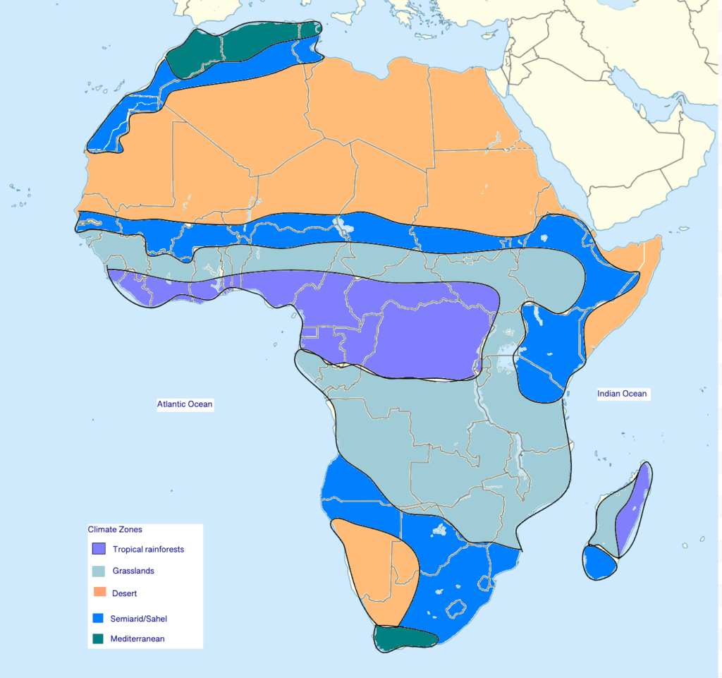
The Five Primary Climate Zones
Understanding Africa’s five climate zones provides a window into how life differs across the continent.
- Deserts (e.g., the Sahara)
- The Sahara is the largest hot desert in the world.
- Low rainfall, intense heat, and limited plant life are common.
- Trade routes across the Sahara historically focused on valuable goods like salt.
- Semiarid Regions (e.g., the Sahel)
- The Sahel (meaning “shore” or “coast” in Arabic) lies just south of the Sahara.
- It experiences slightly more rainfall, enabling limited farming and herding.
- Nomadic lifestyles emerged for survival due to harsh conditions.
- Savannah Grasslands
- Found in broad sections of central and southern Africa.
- Known for wide-open lands suitable for grazing and grain crops.
- This zone has supported large-scale agriculture and diverse wildlife.
- Tropical Rainforests
- Located along the Equator, where rainfall is abundant year-round.
- Dense forests support crops like kola trees and yams.
- Trade in goods like gold thrived in forest-based societies.
- Mediterranean Zone
- Found in the northernmost and southernmost parts of Africa.
- Cool, wet winters and hot, dry summers benefit specialized farming.
- Some of the earliest civilizations emerged in these regions, taking advantage of coastal trade.
Major Water Bodies
Seas and oceans border Africa on nearly all sides. These bodies of water include the Red Sea, the Mediterranean Sea, the Atlantic Ocean, and the Indian Ocean. They have long served as channels for trade, migration, and cultural exchange.
Africa’s five major rivers are equally vital for connecting the continent’s interior regions:
- Niger River
- Congo River
- Zambezi River
- Orange River
- Nile River
Each river system nurtures fertile land along its banks, thereby supporting farming, fishing, and settlement growth. Consequently, these waterways also provided travel routes linking inland communities to coastal ports.
How Africa’s Varied Landscape Affects Settlement and Trade
Topography, climate, and water availability play significant roles in determining where people settle and develop trade networks. Throughout African history, communities have chosen areas with reliable resources and accessible locations. Therefore, the Sahel and savannah regions became prime landscapes for agricultural and pastoral practices.
Historical Importance of Natural Features
Parts of Africa enjoyed early contact with other civilizations due to their proximity to the Red Sea, the Mediterranean Sea, and the Indian Ocean. For example, North African societies traded extensively with Mediterranean empires. Moreover, East African regions connected with Middle Eastern and Asian merchants through the Red Sea and Indian Ocean trade routes. These interactions enriched the African landscape with innovations in technology, religion, and governance.
Key Settlements in the Sahel and Savannah
- Water Routes and Trade Connections
- Major rivers, such as the Niger, linked interior markets to coastal centers.
- Lakes also acted as gathering points for merchants and travelers.
- Such routes fostered trade in gold, salt, livestock, and grains.
- Fertile Land for Agriculture and Nomadic Herding
- The Sahel’s semiarid climate allowed both limited farming and herding.
- The savannah provided plenty of room for livestock and grain cultivation.
- Communities developed flexible strategies to cope with changing rainfall patterns.
- Cultural Regions and Trade Patterns
- Regions varied in rituals, languages, and customs yet maintained lively commercial ties.
- The Sahel worked as a bridge between North African desert trade and southern forest resources.
- Over time, these exchanges advanced new ideas and technologies, such as metalworking skills and architectural styles.
Analysis of Trade Routes
- Desert traders in the north packed caravans with salt.
- Sahel communities received salt in exchange for livestock and surplus grain.
- Savannah kingdoms traded grains and other crops with forest towns supplying gold, kola nuts, and yams.
- Coastal merchants distributed goods overseas, adding foreign imports to regional markets.
Variations in Climate and Their Impact on Trade
Climatic differences across Africa shape the economic pursuits of each region. Consequently, a community’s lifestyle often focuses on available local resources and adaptable trade practices.
- Desert and Semiarid Areas (e.g., the Sahara and the Sahel)
- Nomadic herders move in search of food and water.
- Salt remains a key commodity due to its function in preserving food.
- Trade caravans handle long journeys across harsh landscapes, using camels as sturdy pack animals.
- Sahel: Livestock Trade
- The semiarid environment supports goats, sheep, and cattle.
- Residents trade these animals with neighboring regions, sometimes swapping them for staple crops or salt.
- Herders frequently manage mobile encampments that shift with rainfall patterns.
- Savannah: Grain Crop Cultivation
- Reliable rain makes savannahs excellent for producing millet, sorghum, and other grains.
- Farming communities grew into major kingdoms, partly by controlling trade networks.
- Grains were exchanged for salt, livestock, and luxury goods passing through the region.
- Tropical Rainforests
- Abundant rainfall encourages kola nut production and yam farming.
- Gold deposits near certain rainforest regions attracted merchants from far away.
- Dense forests often required specialized forms of travel, such as canoe routes along rivers.
Example: Case Study of Trade in the Sahel Region
Sahelian kingdoms saw wealth flow in and out of their territories as caravans transported salt from the Sahara to regions farther south. Kings and local leaders imposed taxes on merchants, strengthening their resources and power. Over time, some areas became famous for learning centers, metalworking, and advanced architecture. As a result, the Sahel emerged as an unforgettable chapter in African history, characterized by trade, interaction, and diverse lifestyles.
Conclusion: The Impact of Geography on African Cultures
Africa’s varied landscapes have profoundly influenced settlement patterns, trade networks, and cultural identities. Harsh climates encouraged innovations in agriculture, travel, and resource management. At the same time, fertile land and major waterways supported the rise of prosperous kingdoms in the savannah and Sahel. Across the continent, societies devised distinct solutions to cope with local challenges and seize economic opportunities.
This interplay between environment and community remains a critical factor in understanding the foundation of African civilizations. Geographic conditions continue to shape how people live, work, and connect today. Exploring the depth of this diverse African landscape enriches knowledge of African heritage and emphasizes why Africa’s history is so dynamic.
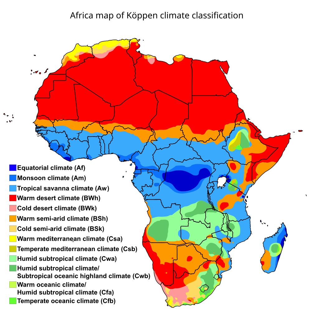
Required Source: Map Showing the Major Climate Regions of Africa
A visual resource, “Map Showing the Major Climate Regions of Africa,” offers an illustrative guide to the deserts, semiarid zones, savannah areas, tropical rainforests, and Mediterranean coastlines. Reviewing this physical geography map of Africa highlights how each climate zone transitions from one to another across the continent. Notably, it pinpoints key rivers like the Niger and Congo, illustrating how they traverse multiple climate zones.
This map also reveals trade corridors, such as the route across the Sahel, where camel caravans linked savannah communities to desert merchants in North Africa. By studying this source, it becomes clear why certain kingdoms developed in transitional zones with ready access to water, farmland, or trade pathways. Consequently, the map stands as a crucial tool in grasping how environment and history intertwine.
VI. Quick Reference Vocabulary Chart
Below is a chart of key terms and definitions related to Africa’s geography. This table can be copied and pasted into a Google Doc for quick reference.
| Term | Definition |
| Sahara | The world’s largest hot desert, covering much of Northern Africa. |
| Sahel | A semiarid region south of the Sahara, serving as a transition zone to the savannah. |
| Savannah Grasslands | Vast grasslands in central and southern Africa, supporting agriculture and livestock. |
| Tropical Rainforests | Equatorial forests with heavy rainfall, home to crops like kola trees and regions with gold deposits. |
| Mediterranean Zone | Coastal areas in northern and southern Africa, featuring wet winters, dry summers, and favorable trade opportunities. |
| Niger River | One of Africa’s key rivers, flowing through several West African nations and enabling trade and settlement. |
| Congo River | The world’s deepest river, winding through the central rainforest region of Africa. |
| Zambezi River | A major river in southern Africa known for Victoria Falls and its impact on regional trade. |
| Sahelian Trade | An economic system where salt, livestock, and grains were exchanged between the desert and forest areas. |
| Kola Nuts | A major trade good from tropical rainforests used for flavoring and cultural ceremonies. |
Sharpen Your Skills for AP® African American Studies
Are you preparing for the AP® African American Studies test? We’ve got you covered! Try our review articles designed to help you confidently tackle real-world AP® African American Studies problems. You’ll find everything you need to succeed, from quick tips to detailed strategies. Start exploring now!
Need help preparing for your AP® African American Studies exam?
Albert has hundreds of AP® African American Studies practice questions, free response, and full-length practice tests to try out.


