What We Review
Introduction
Geography plays a vital role in shaping the climate experienced around the world. Climate encompasses long‑term patterns of temperature, precipitation, and other atmospheric conditions. These patterns depend not only on solar energy but also on geologic factors like mountains and ocean currents. Therefore, examining how Earth’s surface features interact with the atmosphere illuminates the processes that create diverse weather and climate conditions worldwide, highlighting the connection between climate and geography.
Geography influences climate through various mechanisms. Mountain ranges often block moisture, while differing latitudes receive varying amounts of solar radiation. Consequently, geographic location helps determine whether an environment becomes a lush rainforest or an expansive desert. For AP® Environmental Science students, it is essential to see how terrain, oceans, and human activities shape both weather and long‑term climate conditions. Understanding these connections helps explain phenomena such as monsoons, rain shadows, and temperature gradients between regions.
Understanding Weather vs. Climate
Weather describes the short‑term changes in atmospheric conditions, which can vary from day to day or even hour to hour. Climate, on the other hand, refers to the average weather patterns observed over an extended period—typically decades. Therefore, a single rainy afternoon does not alter a location’s overall climate. Instead, climate indicates what general conditions can be expected throughout the year.
- Weather: Short‑term conditions (e.g., daily rain, temperature fluctuations).
- Climate: Long‑term patterns (e.g., average temperature and precipitation over decades).
For example, suppose a city experiences a sudden temperature drop from 20 °C (68 °F) to 10 °C (50 °F) in one day. That event is weather. However, if that city usually has mild summers and cold winters year after year, that pattern reflects its climate.
The Role of the Sun in Climate
The sun’s energy drives nearly all weather processes on Earth. Solar radiation warms the surface, heats the oceans, and fuels the formation of wind. However, solar energy is not distributed evenly. Because Earth is spherical, regions near the equator receive more direct sunlight, and polar regions receive sunlight at a lower angle.
When sunlight strikes Earth’s surface at an angle \theta, the intensity of solar radiation I can be approximated by:
I = I_0 \cos(\theta)Here, I_0 represents the maximum intensity at the equator, and \theta is the angle at which sunlight hits the surface. Therefore, the farther from the equator a region lies, the less direct the angle of sunlight, and the cooler its average climate becomes. Meanwhile, equatorial regions remain warm throughout the year because they consistently receive high levels of solar radiation.
Example: The Equator vs. Polar Regions
At the equator, the sun’s rays shine almost directly overhead, concentrating energy over a smaller area. Consequently, temperatures remain high, and rainfall is often abundant. In contrast, polar regions receive sunlight at an oblique angle, reducing energy input and leading to much colder conditions overall.
Geologic Factors Influencing Climate
Geologic factors include the distribution of mountains, valleys, and ocean basins. By shaping wind currents and precipitation patterns, these landforms alter local climates. Mountains in particular have a dramatic effect on rainfall. When moist air encounters a mountain range, it is forced to rise, cool, and condense into precipitation. This process leads to lush vegetation on the windward side but can create a dry zone on the leeward side.
Discussion of Mountains and Precipitation
High mountain ranges encourage orographic precipitation, which occurs when airflow is uplifted by terrain. The moisture condenses into clouds, eventually releasing rain or snow. Further downwind, significantly drier air descends, causing reduced precipitation.
Example: The Himalayas and Indian Monsoons
The Himalayas are among the tallest mountains on Earth. Monsoon winds from the Indian Ocean carry enormous amounts of moisture northward. However, as these winds rise over the Himalayan range, most of the water vapor condenses and falls as rain. As a result, the regions south of the Himalayas receive abundant rainfall, while the Tibetan Plateau to the north remains comparatively arid.
Geographic Factors and Weather Patterns
Geographic factors also shape broader weather patterns, such as prevailing winds and ocean currents. Winds transport heat and moisture across continents, while ocean currents move warm and cold water around the globe. Consequently, coastal regions directly influenced by ocean currents can experience milder climates than inland areas at the same latitude.
Rain Shadow Effect
One striking consequence of mountainous terrain is the rain shadow effect. When moist air travels across a mountain range, most precipitation falls on the windward slope. By the time the air crosses the peak, it has shed much of its water vapor. Thus, the air descending on the leeward side is dry.
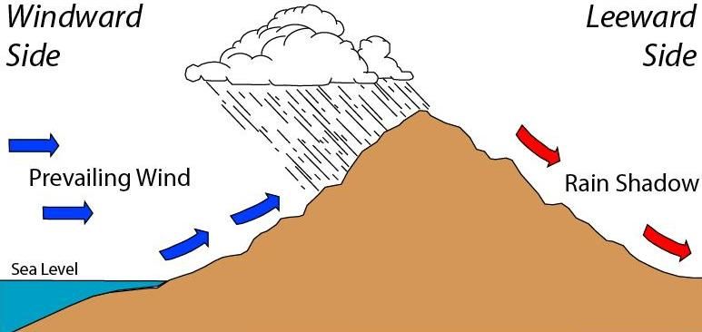
Step‑by‑Step Example: Rain Shadow
- Warm, moist air approaches a mountain from the windward side.
- The air rises along the mountain slope, expanding and cooling.
- Water vapor condenses and falls as precipitation on the windward side.
- The now drier air passes over the mountain’s summit.
- The air descends on the leeward side, warming and retaining any remaining moisture.
- As a result, the leeward region receives little precipitation, forming a dry zone.
This effect can be seen near many mountain ranges worldwide, including the Rockies in North America and the Andes in South America.
Climate Zones and Their Characteristics
Geographic and geologic factors help define distinct climate zones: tropical, temperate, and polar. Latitude, elevation, and proximity to oceans or mountains all play critical roles in the formation of these zones.
- Tropical Zones: Located near the equator, where direct solar radiation leads to warm temperatures year‑round. Regular rainfall supports diverse ecosystems such as rainforests.
- Temperate Zones: Found between the tropics and polar regions. These areas typically enjoy moderate temperatures and four distinct seasons.
- Polar Zones: Near Earth’s poles, where solar radiation arrives at a low angle, resulting in frigid conditions. Polar climates have short growing seasons and limited precipitation.
Example: Comparing the Mediterranean and Desert Climates
A Mediterranean climate often features mild, rainy winters and hot, dry summers. Locations around the Mediterranean Sea benefit from warm ocean currents that moderate temperatures. By contrast, desert climates receive sparse rainfall due to prevailing high‑pressure systems and often the rain shadow effect. While both environments may have hot summers, desserts see far less moisture overall, severely limiting vegetation.
The Interplay Between Geography and Climate Change
Today, human activities such as deforestation and the burning of fossil fuels alter geographic and climate factors on a global scale. For instance, removing large swaths of forest can change local evaporation rates and temperature balances. Changes to ocean temperatures, driven by increased greenhouse gas concentrations in the atmosphere, can modify global currents. Furthermore, industrial emissions that add carbon dioxide to the carbon cycle influence how much solar radiation is trapped, affecting temperature and precipitation patterns worldwide.
In AP® Environmental Science, many topics, such as the population growth model, intersect with climate discussions. As human populations expand, demands on land resources rise, potentially reshaping regions and further affecting climate systems. Meanwhile, efforts to switch to renewable energy can reduce carbon emissions and mitigate some consequences of climate change. However, it remains crucial to remember that regional geography will always affect how these changes occur in different parts of the world.
Conclusion
Geography and climate are tightly linked. Physical landscape features, including mountains and ocean currents, modify the distribution of heat and moisture across Earth’s surface. Regions near the equator receive more direct sunlight, supporting lush tropical environments. Meanwhile, regions in rain shadows often remain arid or semi‑arid. Understanding these systems helps explain why specific parts of the planet tend to be warm or cold, wet or dry, and how these conditions might shift with human influence.
Climate science goes beyond daily weather observations. It extends into understanding latitude, elevation, Earth–Sun relationships, and even human interventions in natural processes. Appreciating the significance of these geographic and geologic factors builds a solid foundation for deeper study in AP® Environmental Science. This knowledge can inform responsible decision‑making regarding land use, conservation, and sustainability. Ultimately, recognizing how Earth’s terrain shapes climate patterns is a critical step toward tackling environmental challenges now and in the future.
Key Vocabulary
- Climate: The average weather conditions in a region over a long period, typically 30 years or more.
- Geography: The physical features of Earth’s surface, including landforms, latitude, and proximity to bodies of water.
- Rain Shadow: A dry area on the leeward side of a mountain, where precipitation is blocked by the mountain range.
- Weather: The current state of the atmosphere, including temperature, precipitation, and wind speed at a given time.
- Geologic Factors: Natural features (e.g., mountains, ocean basins) that affect climate and weather patterns by influencing airflow and precipitation.
Sharpen Your Skills for AP® Environmental Science
Are you preparing for the AP® Environmental Science test? We’ve got you covered! Try our review articles designed to help you confidently tackle real-world AP® Environmental Science problems. You’ll find everything you need to succeed, from quick tips to detailed strategies. Start exploring now!
- AP® Environmental Science: 4.4 Review
- AP® Environmental Science: 4.5 Review
- AP® Environmental Science: 4.6 Review
- AP® Environmental Science: 4.7 Review
Need help preparing for your AP® Environmental Science exam?
Albert has hundreds of AP® Environmental Science practice questions, free response, and full-length practice tests to try out.


