What We Review
Introduction
Plate tectonics describes how the Earth’s outer shell is divided into several plates that move slowly over the planet’s surface. These plates—like puzzle pieces—constantly interact, causing both gradual and sudden changes. Such changes include mountain building and volcanic eruptions, which, in turn, can impact the environment through processes like releasing gases into the carbon cycle.
Furthermore, mapping plate boundaries connects with AP® Environmental Science learning objectives. Studying these boundaries offers a lens for understanding how geological processes shape ecosystems, influence the global carbon cycle, and even help locate renewable energy sources such as geothermal power.
Understanding the Earth’s Layers
The Earth consists of three main layers: the crust, the mantle, and the core. It helps to visualize these layers like the layers of an egg, although Earth’s internal structure is far more complex.
- Crust: This outermost layer is relatively thin and contains the continents (continental crust) and ocean basins (oceanic crust). Continental crust is thicker but less dense, while oceanic crust is thinner and denser.
- Mantle: Located beneath the crust, the mantle contains hot, semi‑solid rock that circulates in convection currents. These currents drive plate movement at the surface by transferring heat from the interior to the crust.
- Core: The core is divided into two parts: a liquid outer core and a solid inner core. The core is primarily composed of iron and nickel, and it supplies much of the heat that powers convection in the mantle.
These layers interact through the transfer of heat. Consequently, the movement in the mantle influences how tectonic plates shift, collide, or pull apart over time.
What Are Tectonic Plates?
Tectonic plates are massive pieces of the lithosphere—the rigid crust plus the uppermost mantle. Some of the major plates include the North American Plate, the Eurasian Plate, the African Plate, and the Pacific Plate. Although plates move very slowly, their interactions can yield dramatic surface changes.
Visualizing plate movement can be done by examining patterns of volcanic arcs and seafloor spreading zones around the globe. While the pace of plate motion is typically measured in centimeters per year, over millions of years, these small movements add up and shape continents, basins, and mountain ranges.
Types of Plate Boundaries
Plate boundaries mark the regions where plates meet, and different forms of contact lead to various geological outcomes. These boundaries reflect the specific type of motion between plates. Therefore, recognizing and labeling this motion can help identify potential hotspots for geological events like earthquakes, volcanoes, and mountain building.
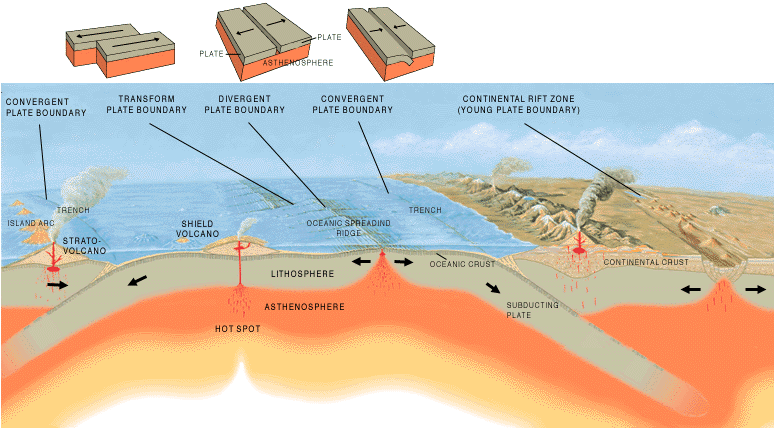
Convergent Boundaries
Convergent boundaries occur where two plates move toward each other. At these boundaries, one plate often goes beneath the other in a process called subduction. Convergent boundaries can result in mountains, island arcs, earthquakes, and volcanoes.
- If an oceanic plate collides with a continental plate, the denser oceanic plate subducts below the lighter continental plate.
- When two continental plates collide, they fold upward to form mountain ranges.
- Subduction zones frequently produce volcanoes because melting rock under high pressure can rise to the surface.
Real‑world events, such as the formation of the Himalayas, highlight the power of convergent boundaries.
Step‑by‑Step Example: Formation of the Himalayas
- Two continental plates (the Indian Plate and the Eurasian Plate) began moving toward each other.
- Over time, the edges of these plates converged, and neither plate was dense enough to subduct easily.
- As a result, the crust folded and uplifted, slowly building the Himalayan mountain range.
- Continuous compression still causes the Himalayas to grow in height every year.
Because of these continuous forces, convergent boundaries remain sites of ongoing earthquakes and mountain-building processes.
Divergent Boundaries
Divergent boundaries form where two plates move away from each other. These boundaries commonly appear beneath oceans, fostering processes like seafloor spreading. Divergent boundaries can result in new oceanic crust, rift valleys, volcanoes, and earthquakes.
- Plates separate due to convection currents in the mantle, and magma rises to fill the gaps, solidifying into new crust.
- If divergent motion occurs on a continent, a rift valley can form, as seen in East Africa.
Step‑by‑Step Example: Formation of the Mid‑Atlantic Ridge
- The North American Plate and the Eurasian Plate are pulling apart beneath the Atlantic Ocean.
- Hot magma from the mantle rises up through this gap.
- The magma cools and solidifies, thus creating new oceanic crust.
- Over time, the sea floor spreads outward, widening the Atlantic basin bit by bit.
Divergent boundaries often lead to volcanic activity. Moreover, these volcanic events can contribute gases to Earth’s atmosphere, which might then be part of the broader carbon cycle that AP® Environmental Science also investigates.
Transform Boundaries
Transform boundaries emerge where two plates slide side by side in opposite directions. These boundaries can result in earthquakes because friction and stress accumulate until released across fault lines like the San Andreas Fault in California.
- No significant subduction or magma creation occurs here.
- The friction between plates builds stress, which releases as seismic waves.
- Transform boundaries can produce powerful earthquakes but fewer volcanoes.
Step‑by‑Step Example: San Andreas Fault in California
- The Pacific Plate moves northwest relative to the North American Plate.
- This lateral motion occurs along the San Andreas Fault line.
- As the plates grind past each other, stress builds up.
- Suddenly, the stress overcomes the locked fault, releasing energy as an earthquake.
Because California is a populous area, earthquakes along this transform boundary can pose substantial risks to infrastructure and human safety.
Mapping Plate Boundaries
Maps illustrating the global distribution of earthquakes, volcanoes, and faults reveal distinct patterns. Plate boundaries show up as zones of frequent seismic activity. Therefore, by examining a world map of volcanic regions, one can see how volcanic arcs often align with subduction zones.
These maps help locate island arcs, hot spots, and other tectonic features. In an AP® Environmental Science context, such maps are valuable for predicting risks, managing natural resources, and planning for potential hazards such as tsunamis or volcanic eruptions.
Understanding Earthquakes
Earthquakes occur due to the sudden release of energy built up in the Earth’s crust. An earthquake happens once stress overcomes a locked fault, causing the release of stored energy as seismic waves. Faults can lock when the friction between the two sides is too great for the plates to move freely. When enough stress accumulates, the fault breaks and triggers quakes that can vary in strength.
Geologically, these quakes often appear along convergent and transform boundaries, since these areas experience significant stress. Although divergent boundaries also produce earthquakes, they are generally weaker compared to those seen at convergent or transform zones.
Real‑world implications include damage to roadways, buildings, and essential services. For instance, major earthquakes can disrupt pipelines carrying water or energy resources, affecting local communities. Because of this, studying plate tectonics in AP® Environmental Science also ties into evaluating geohazards, social impacts, and sustainable development planning.
Conclusion
Plate tectonics provides a unifying explanation for many of Earth’s dynamic processes, such as mountain formation, earthquakes, and volcanic activity. Understanding how plates converge, diverge, or slide past one another is essential for making sense of the planet’s evolving surface. Moreover, these movements influence the carbon cycle through volcanic gas emissions and can create opportunities for renewable energy extraction, such as geothermal power.
Because plate motions produce varied landscapes, it is crucial to recognize their role in shaping our environment. By mapping plate boundaries and examining geological events, one gains valuable insights that can guide resource management and risk mitigation strategies. Ultimately, exploring plate tectonics within AP® Environmental Science unites environmental awareness with geology, highlighting the power and complexity of our planet.
Important Vocabulary
- Tectonic Plate: A large section of Earth’s lithosphere that moves over the semi‑fluid mantle below.
- Convergent Boundary: A location where two plates collide, often causing mountains, volcanoes, or subduction.
- Divergent Boundary: A type of boundary where plates pull apart, forming new crust at mid‑ocean ridges or rift valleys.
- Transform Boundary: A place where plates slide past each other horizontally, typically creating earthquakes.
- Subduction: The process in which one plate, usually an oceanic plate, moves under another plate and sinks into the mantle.
- Fault: A fracture in Earth’s crust where stress can accumulate and eventually cause an earthquake.
Sharpen Your Skills for AP® Environmental Science
Are you preparing for the AP® Environmental Science test? We’ve got you covered! Try our review articles designed to help you confidently tackle real-world AP® Environmental Science problems. You’ll find everything you need to succeed, from quick tips to detailed strategies. Start exploring now!
- AP® Environmental Science: 3.6 Review
- AP® Environmental Science: 3.7 Review
- AP® Environmental Science: 3.8 Review
- AP® Environmental Science: 3.9 Review
Need help preparing for your AP® Environmental Science exam?
Albert has hundreds of AP® Environmental Science practice questions, free response, and full-length practice tests to try out.
